Seamless Digital Chart of the World
An enhanced and updated global GIS basemap – Version 10.5 Update released April 2017
For more info or to purchase, click here to access form.
The Seamless Digital Chart of the World (SDCW) is a unique, updated basemap provided in an easy-to-use, seamless GIS format. The SDCW is based on the best currently-available global vector base map, Digital Chart of the World (Vector Smart Map 0, Edition 5 from NGA).
It comes with a variety of enhancements and updates which make it more easily usable, at a broader range of scales, and with better cartographic results than the freely available Digital Chart of the World from which it largely derives.
This data product serves as a high-quality GIS basemap for cartographers and researchers.
Major features
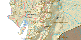
- Proprietary adaptation of the Digital Chart of the World in a seamless Esri shapefile (.shp) data format, eliminating duplicate layers and tile boundary artifacts (see Sample Maps)
- Updated country and province polygons (see Sample Maps)
- Layer files and project files for ArcGIS 10.1 that simplify creation of maps with attractive, readable symbology
- All features appear in global-extent Esri shapefiles or file geodatabases - features customarily drawn with borders (countries, states/provinces, inland water areas, etc. are merged across DCW tiles and libraries
- First-level political subdivisions (states/provinces) are periodically updated, and country polygons (not included in VMAP 0) are created from the updated subdivisions. Second-level subdivisions have been added for India, Sri Lanka, and China
- Inland water areas and watercourse lines have relative-flow attributes, allowing appropriate amounts of water to be shown at different scales and for different cartographic requirements
- An improved set of populated place points, ranked by population and with improved names, allows improved symbology, labeling and scale-appropriate display of place
New in Version 10.5
- Topology has been created for political, coastline and ocean feature classes to clean up gaps and features which didn’t align along borders.
- First level administrative areas updated to approximately mid-2014. India and Sri Lanka districts to 2011 census. This has involved changes in over 30 countries and over 300 provinces.
- File geodatabase, SDCW.gdb is included. This puts a copy of almost all shape file data in a single file geodatabase.
- South Sudan has been split from Sudan.
- Fields for the GENC (Geopolitical Entities, Names, and Codes) 2 and 3 letter codes have been added for countries and the administrative code is included for provinces.
- FIPS 10-4 (GEC) codes added for all coastlines and political boundaries. This allows the ability to create subsets (Definition Queries) of these features.
- Some other minor changes and updates.
System requirements
- GIS software capable of reading Esri shapefile format (.shp) and file geodatabase format.
- Shapefiles have been tested in Esri's ArcGIS 10.1 – 10.5.
- Projects and layers tested in ArcGIS 10.1.
- Sample ArcGIS project with wizard macro has been tested in ArcGIS 10.1 and above.
- Windows system to run self-extracting .exe installation files. This need not be the computer running the GIS system, but must be able to write data to a location accessible by the GIS system.
All other technical specifications can be found in the following PDF document:
Related Products
The Seamless Digital Chart of the World is the preferred base map for the World Language Mapping System (WLMS).