World Language Mapping System
Explore Your World Through the Lens of Language!
For more info or to purchase, click here to access form.
Include language data in your GIS analysis with this one-of-a-kind resource.
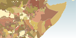
The World Language Mapping System (WLMS) Version 19 is the most comprehensive, up-to-date, and trusted geographic dataset of the point and area (polygon) locations of the world's nearly 7,100 living language groups.
The World Language Mapping System (WLMS) has been a project of Global Mapping International (GMI) and several contributors for over 25 years.
The data is provided in Esri shapefile (.shp) and file geodatabase formats for GIS systems. The source for language names and codes is 19th edition (2016) ISO 639-3 standard. ArcGIS layer files are included to help with symbology.
Linguists, cultural geographers, and other researchers will find this data valuable in understanding the locations and distribution of languages throughout the world. Innovative uses have included ecology (studies of the relationship between human cultural diversity and biodiversity), political science (studies of relationship between armed conflict and linguistic boundaries), and military/counterterrorism (assignment of appropriate linguists/translators to operations in specific locations).
Major features:
- Language locations both as points and polygons (of language homelands), in Esri shapefile (.shp) format and file geodatabase.
- Polygons for mixed language areas
- Designed to overlay with the Digital Chart of the World / VMAP0 basemaps
- Layer files and mxd files for ArcView 10.1 or above
New Features in Version 19
- Point and polygon data have been updated to correspond with the 19th Edition (2016) ISO 639-3 standard. Countries which had a lot changes include South Africa, Ghana, Malaysia, Peru, Paraguay, Georgia.
- Over 60 languages were added as point locations so all living languages in 19th edition (2016) ISO 639-3 standard will have at least a point.
- Updated list of immigrant, extinct, and sign languages.
For other new features click here.
System requirements
- GIS software capable of reading Esri shapefile format (.shp)
- Shapefiles have been tested on Esri's ArcView 10.1-10.5
- Full use of project and layer files requires ArcView 10.1 or above
- Windows system to run self-extracting .exe installation files. This need not be the computer running the GIS system, but must be able to write data to a location accessible by the GIS system.
All other technical specifications can be found in the following PDF document:
Article from ESRI's ArcNews
Read the article by ESRI from Spring 2006, outlining the details of the World Language Mapping System.
Related Products
Most customers prefer to bundle the World Language Mapping System with the high-quality basemap Seamless Digital Chart of the World (SDCW).